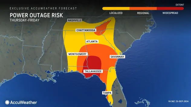
People in the Florida Panhandle, Big Bend region and much of the central and eastern Gulf coast need to complete preparations for major hurricane impacts by Wednesday night before hazardous conditions arrive by Thursday.
Key takeaways:
•A major hurricane is poised to make landfall in the United States later this week
•Helene will likely be the name given to the brewing storm
•This will be “a large storm with life-threatening impacts” hundreds of miles away from where it makes landfall
A major hurricane is coming to the Gulf of Mexico. AccuWeather meteorologists warn that communities along the central and eastern Gulf coast only have a few days to prepare for the fast-brewing, quick-moving storm, which can potentially bring life-threatening storm surge, flooding rainfall, and destructive winds.
The western Caribbean to the Gulf of Mexico has been an area highlighted by AccuWeather meteorologists as a hot spot for tropical activity since the middle of September.
Showers and thunderstorms quickly gathered over the weekend in the western Caribbean and adjacent land areas in Central America. Localized flash flooding and mudslides will occur in areas surrounding the western Caribbean from Jamaica and Cuba to southeastern Mexico, Belize, Honduras and Nicaragua.
AccuWeather began designating the brewing system as a tropical rainstorm this past weekend to raise public awareness and issue its own track map to help people and officials plan ahead. On Monday morning, the National Hurricane Center (NHC) issued an advisory for Potential Tropical Cyclone 9. When it is upgraded to a tropical storm with sustained winds of at least 39 mph, it will be given a name.
The next name on the list is Helene.
“The combination of deep warm water (ocean heat content) and low disruptive breezes (wind shear), should assist in rapid strengthening when over the Gulf of Mexico from Wednesday to Thursday,” AccuWeather Chief On-Air Meteorologist Bernie Rayno said.
“Most likely, the storm will create its own environment and bring a surge in moisture to the currently dry air over the Gulf,” Rayno added.
AccuWeather is expecting the storm to make landfall as a major hurricane of Category 3 strength (sustained winds of 111-129 mph) on the Saffir-Simpson Hurricane Wind Scale. However, it could reach Category 4 status (130-156 mph) at some point while it is over the Gulf of Mexico.
At this time, the storm’s eye is most likely to track along the Gulf coast from the eastern tip of Louisiana to the central part of the Florida Peninsula.
Continue reading at AccuWeather
For more on hurricane season and the utility industry, see how Duke Energy is strengthening the grid, ask yourself if you are making these heat related illness mistakes, and make sure you are stocked up on the must haves for storm season.


0 Comments