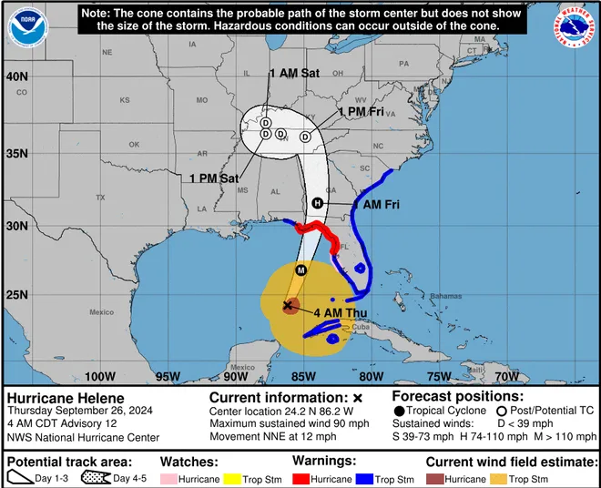
People in the Florida Big Bend region and much of the eastern Gulf coast need to complete preparations for major hurricane impacts by Wednesday night before hazardous conditions arrive on Thursday.
Key takeaways:
•Helene is poised to make a quick landfall in Florida’s Big Bend area as a Category 4 hurricane Thursday evening.
•Widespread extreme damage will occur where the eye wall moves ashore.
•Life-threatening impacts will occur hundreds of miles inland due to Helene’s large size.
As the hours continue to tick away before Helene makes landfall in northern Florida late Thursday with life-threatening conditions and the potential for widespread extreme property damage, it will strengthen quickly and become a major hurricane, AccuWeather meteorologists warn.
As of Thursday morning, Helene was a Category 2 hurricane with 100 mph sustained winds. However, AccuWeather meteorologists expect Helene to continue to rapidly intensify and gain at least 35 mph in terms of wind strength in less than 24 hours.
Helene is forecast to peak as a Category 4 hurricane on the Saffir-Simpson Hurricane Wind Scale with maximum sustained winds of 130-156 mph while over the Gulf of Mexico before landfall. Depending on the integrity of the eye wall, Helene could retain that intensity up to the time of landfall Thursday evening.
Hurricane warnings were in effect for the Florida Big Bend area to just north of Tampa, while tropical storm warnings were in effect for much of the rest of the Florida coastline, except for the western part of the Florida Panhandle. Tropical storm warnings were also in effect for the Georgia and South Carolina coasts.
“Confidence continues to grow among our experts for a landfall Thursday evening in the Big Bend area of the Florida Gulf Coast, which is the zone from the eastern part of the Florida Panhandle to the northwestern part of the Florida Peninsula,” AccuWeather Chief On-Air Meteorologist Bernie Rayno said, “At the time of landfall, Helene is expected to be a dangerous major hurricane.”
The latest information suggests that landfall maybe just east of Apalachicola, Florida, and centered more on communities on the shores of Apalachee Bay.
There is still some risk the storm may drift a bit to the west or east, but steering breezes are more deliberate with this storm over the Gulf of Mexico compared to some in the past that have shifted their tracks considerably at the last minute.
Continue reading at AccuWeather
For more on hurricane season and the utility industry, see how Duke Energy is strengthening the grid, ask yourself if you are making these heat related illness mistakes, and make sure you are stocked up on the must haves for storm season.


0 Comments