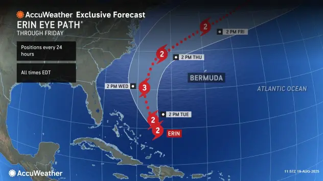
The growing size of the powerful hurricane’s winds and waves will lead to significant flooding and erosion on North Carolina’s Outer Banks throughout the week.
The North Carolina Outer Banks and other beaches along the Atlantic coast of the United States will bear the brunt of Erin as the hurricane grows in size and its winds and waves extend well beyond the eye of the storm, AccuWeather meteorologists warn.
A Tropical Storm Watch has been issued from Beaufort Inlet to Duck, North Carolina, including Pamlico Sound.
The magnitude of the storm surge, waves and winds on the Outer Banks and southeastern Virginia will depend on how close to the coast Hurricane Erin tracks. Erin’s eye is forecast to pass at least 150 miles offshore. Because of the distance, little to no rain from Erin is forecast in eastern North Carolina. Still, impacts along the coast can be significant.
“People on the coast should not just focus on the eye track of a hurricane, especially one that is as large and strong as Hurricane Erin,” AccuWeather Lead Hurricane Expert Alex DaSilva said.
Due to Erin’s already large and growing zone of winds and waves, significant problems associated with a relentless storm surge, flooding and overwash from waves on top of the surge will lead to coastal flooding and erosion on the Outer Banks. The AccuWeather RealImpact™ Scale for Hurricanes in the U.S. is less than one, which will be equivalent to a strong tropical storm in terms of storm surge.
Continue reading at AccuWeather
For more on hurricane season and the utility industry, see how Duke Energy is strengthening the grid, ask yourself if you are making these heat related illness mistakes, and make sure you are stocked up on the must haves for storm season.


0 Comments