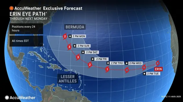
Erin has formed in the eastern Atlantic and is forecast to be the first hurricane and first major hurricane of the 2025 Atlantic season. Erin will be a long-track storm and will eye the United States next week.
A tropical rainstorm in the eastern Atlantic Ocean has evolved into Tropical Storm Erin, and it may be on its way to a major hurricane this week, AccuWeather experts say. Meanwhile, three additional areas are also being monitored for potential tropical development this week.
Tropical rainstorm evolves into Erin
A cluster of showers and thunderstorms that moved off the African coast last week became a tropical rainstorm Sunday morning near the Cabo Verde Islands. Further strengthening has resulted in its official designation as a tropical storm. Erin is expected to rapidly intensify and become a hurricane—the season’s first—later this week and a major hurricane shortly thereafter.
The average date for the first hurricane is Aug. 11, but the first major hurricane typically does not occur until Sept. 1.
“Several factors are working in its favor, including lack of dust, warm water and a lack of disruptive breezes (wind shear),” said AccuWeather Senior Meteorologist Chad Merrill.
There is a large plume of dust and dry air ahead of Erin. Provided the moist, dust-free zone the storm is in now continues to move along, further organization and strengthening will continue.
Continue reading at AccuWeather
For more on hurricane season and the utility industry, see how Duke Energy is strengthening the grid, ask yourself if you are making these heat related illness mistakes, and make sure you are stocked up on the must haves for storm season.


0 Comments